The WayPass
Smart pedestrian crossing system for high-traffic intersections in urban dense cities.
role
Concept, Research, Lead Designer, System Design, 3D Model
Client
LADOT, Atwater CityCouncil
tools
Figma, Adobe CC, Spline, After Effects, Premier Pro
Links
Purpose
Being a pedestrian in Los Angeles is a survival-of-the-fittest experience. Accessibility has been treated as a checkbox, with surface-level ADA compliance failing to address the full spectrum of needs.
Now imagine:
By putting people back at the center of city planning, we can build safer, more inclusive streets that support independence and quality of life.
Research
To ground the concept in real needs, I led a team of three designers through an extensive research process. We combined fieldwork analysis, user interviews, netnography, and competitive analysis to uncover systemic failures in Atwater Village’s pedestrian infrastructure. These methods revealed the gaps in accessibility and safety that WayPass needed to address
Insights
- Crosswalk timing averages 15 seconds, leaving people with disabilities at risk.
- All 3 crosswalks on Glendale Blvd span 1,184 ft (≈3 football fields).
- Inconsistent infrastructure (curb cuts, audio signals, timing) impacts mobility.
- Limited crosswalks correlate with a 30% higher accident rate.

Approach
I owned the full design process from user definition to system prototyping. This included creating a persona and journey map to empathize with mobility challenges, designing user flows to integrate with existing traffic systems, and building both an interactive prototype and a 3D system model. Each phase ensured feasibility while highlighting how WayPass could be integrated into existing infrastructure.
User Persona
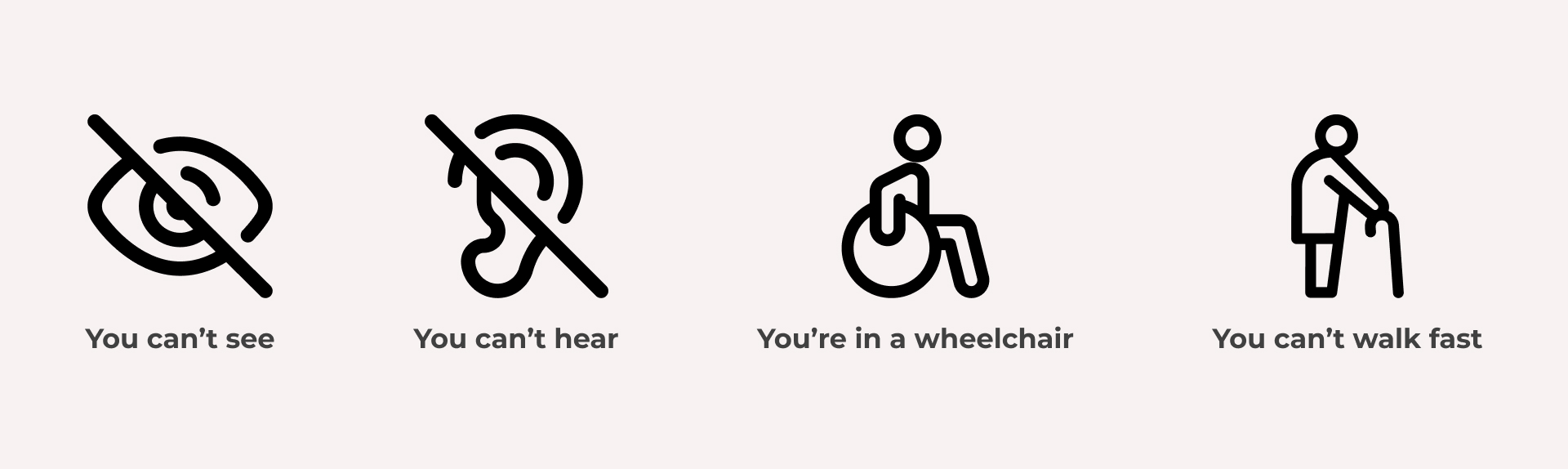
Emily Parker was created as a persona based on data representing the average resident in Atwater. Her goals of staying active and exploring her community are contrasted with frustrations like short crossing times and inaccessible infrastructure. Her challenges are common among pedestrians with limited mobility not just in Atwater, but all across LA.

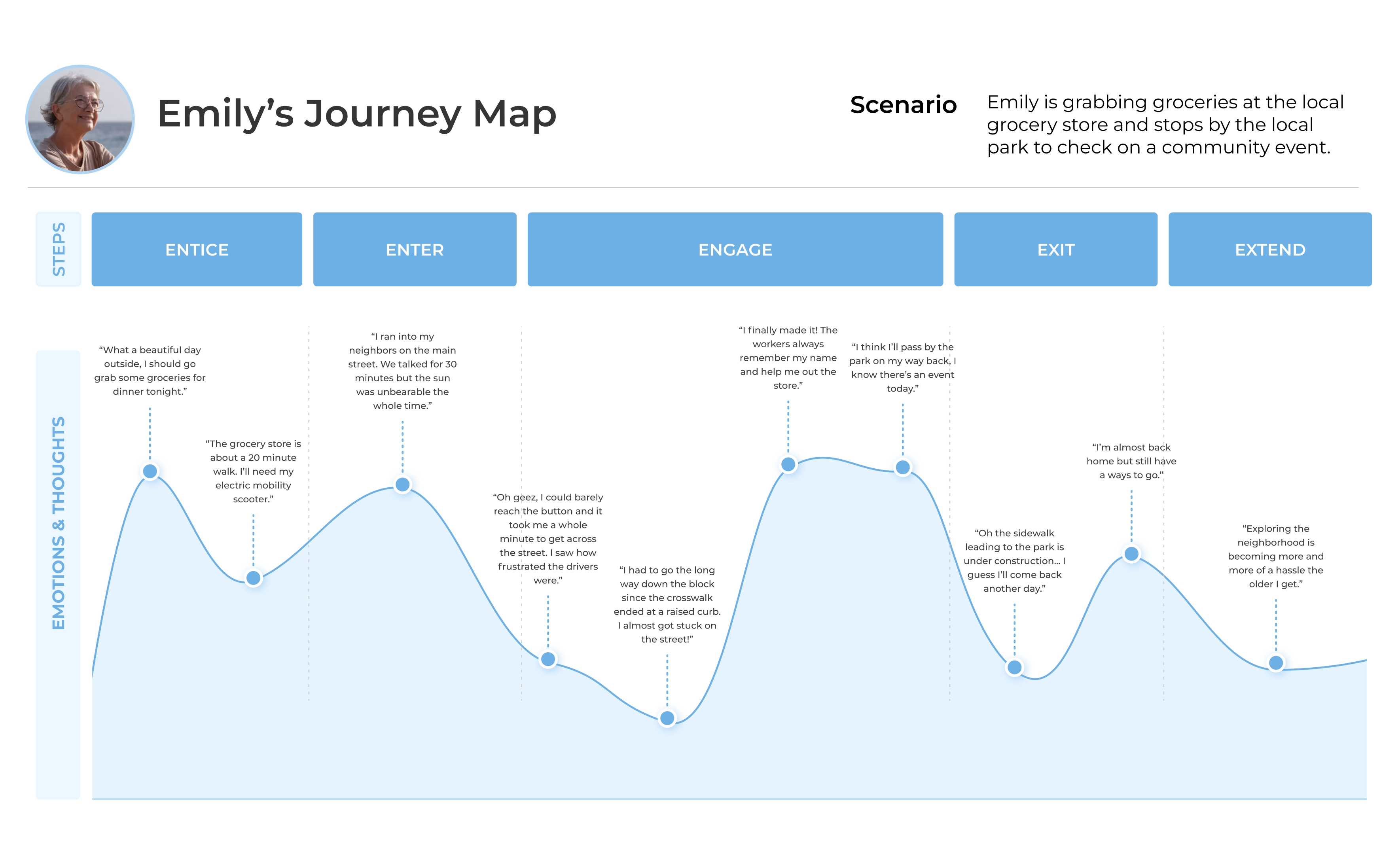
Journey Map
Captured environmental stressors (short crossing times, damaged sidewalks) vs positive reinforcements (community belonging).
User Flow
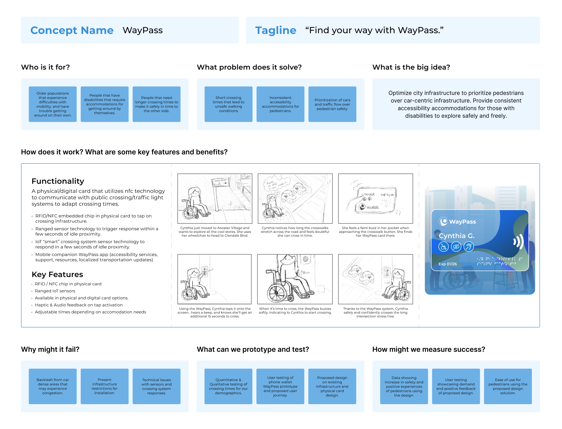
Structured around three phases — Access, Activation, Support — to streamline crosswalk interaction

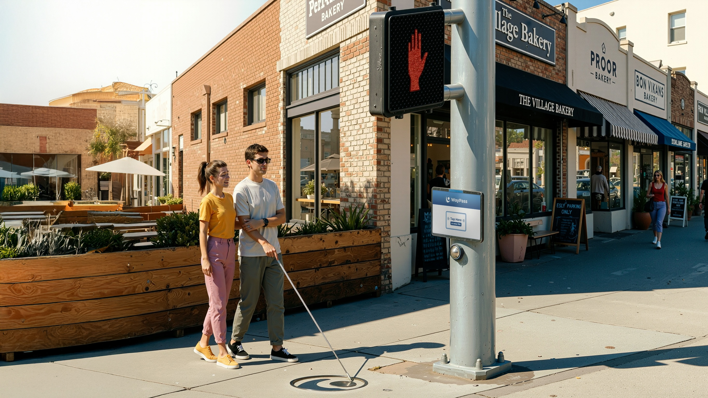
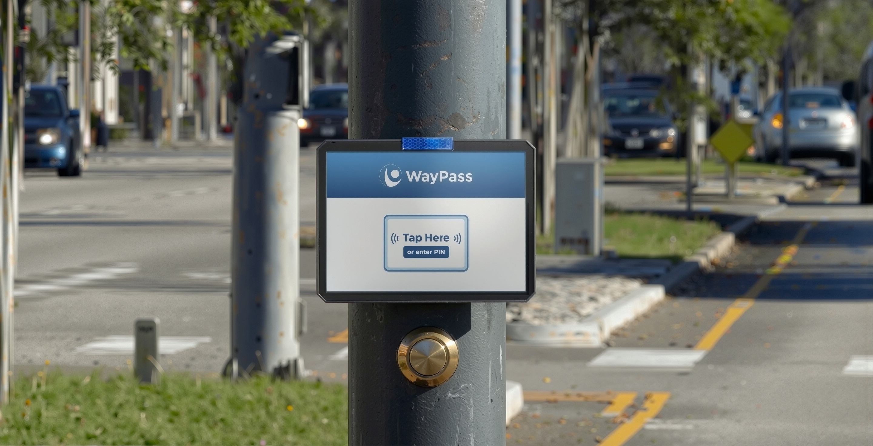
Prototyping
Built an interactive prototype and 3D system model to demonstrate sensor-based activation, audio-visual cues, and infrastructure integration.
Results
To validate the concept, we tested WayPass with both target and non-target users, including three participants with mobility limitations. The focus was on whether the system reduced stress and improved trust in navigating unsafe intersections. User feedback confirmed WayPass was recognized as a solution needed now by the people it was designed for.

WayPass reimagines how cities can respond to aging populations and overlooked mobility needs through augmentation of our infrastructures. By embedding intelligence into crosswalks, WayPass offers a low-friction path to safer, walkable cities.
The next step is to pitch WayPass to LADOT as a scalable pilot for equitable mobility. With the WayPass, this project invites transportation leaders to rethink accessibility as infrastructure intelligence.
Purpose
Being a pedestrian in Los Angeles is a survival-of-the-fittest experience filled with anxiety and hypervigilance every time you step outside.
Now imagine:
These are just some of the everyday struggles older adults and people with disabilities face when navigating the city. Accessibility has been treated as a checkbox with surface-level ADA compliance failing to address the full spectrum of needs.
By putting people back at the center of city planning, we build safer, more inclusive streets that support independence, exploration, and quality of life.
Research
Leading a group of 3 designers, we used fieldwork analysis, user interviews, netnography, and competitive analysis to uncover gaps in accessibility, safety, and urban mobility in Atwater Village. These insights grounded our approach in real needs and exposed the systemic failures of current crosswalk systems.
Fieldwork Analysis
Our on-the-ground observations of Glendale Boulevard in Atwater Village showcased some of the many issues on the main street that serves both as a local shopping district and major commuter route. Examples of these issues below highlight deeper systemic issues in urban mobility.
User Interviews
To better understand the challenges in the area, we conducted three interviews with locals of Atwater Village and visitors of the spaces there. The varying pain points showcased significant mobility and accessibility gaps, emphasizing the urgency of creating a more inclusive urban environment.

Netnography
Next, we conducted extensive desktop research analyzing both primary sources (LA Metro surveys, city planning documents, ADA reports) and secondary sources (academic studies, news articles, community forums). This approach allowed us to gather crucial data about varying challenges and the spectrum of needs.
Insights
✺
The average crosswalk timing in Atwater is 15 seconds, leaving pedestrians with disabilities at higher risk.
✺
The distance of all three crosswalks in Atwater is 1,184ft, the length of roughly 3 football fields.
✺
Inconsistent infrastructure like curb cuts, lack of audio signals, and short crossing times all impact mobility.
✺
Areas with limited crosswalks experience a 30% higher accident rate than areas with well-marked crossings.
Approach
The WayPass was developed through a phased, systems-focused process. My team created a persona and journey map to empathize with target user needs. I then outlined the user flow to incorporate machine learning processes, prototyped, and 3D modeled environmental system behavior and main touchpoints. Each step was to ensure feasibility to bring the concept to life for existing infrastructure.
Concept Map
To define the WayPass system’s purpose, user base, and core functionality, I focused on addressing mobility challenges through features like sensor-based crossing time adjustments, visual/audio feedback, and accessible tools. This map clarified the system’s goal to prioritize pedestrian safety and inclusivity in public spaces.
User Persona
Emily Parker was created as a persona based on data representing the average resident in Atwater. Her goals of staying active and exploring her community are contrasted with frustrations like short crossing times and inaccessible infrastructure. Her challenges are common among pedestrians with limited mobility not just in Atwater, but all across LA. Some of her key defining traits are:
Elderly
Emily is a 72 year old retired elementary teacher. She's lived in Atwater since her 40's and is a known local in her community.
Arthiritis
Due to her age, Emily suffers from arthiritis in her knees. She relies on a cane to walk around, and a scooter for long distances.
Dependent
Emily is aware she can't do the things she used to when she was younger. She notices her shortened stamina and aches every outing.
Journey Map
Emily’s journey map outlines her experience navigating her community as a retiree with mobility challenges. The scenario illustrates her steps through the daily errand of grabbing groceries to visiting a local park for a community event. Emily is met with enviornmental barriers and doubts her abilities.
Highlights
✺
Emily struggles to press pedestrian buttons and reach sidewalks due to poor infrastructure and short crossing times.
✺
She enjoys interacting with neighbors, but environmental stressors like sun exposure and distance wear her down.
✺
Friendly workers and known locations give her a sense of belonging and ease, reinforcing her independence.
✺
Blocked or damaged sidewalks force her to change plans or avoid areas entirely, reducing the trust in her surroundings.
User Flow
The WayPass user flow showcases the streamlined and inclusive process for enhancing pedestrian safety and accessibility. Key interactions showcase integration capabilities for activation with existing traffic systems to ensure a seamless and stress-free crossing experience.
1. Access
Covers everything from the user arriving at the crosswalk to identifying themselves.
2. Activation
Details the confirmation and handoff process between user and system once access is granted.
3. Support
Final stage where system communicates readiness and supports crossing.
Prototyping
To communicate both the functionality and feasibility of WayPass, I built an interactive prototype and 3D model that simulates the full system experience. From user interaction to infrastructure integration, these tools allowed stakeholders to explore how the system works in real time, demonstrating both accessibility and impact.
✺
An interactive screen shows how users can activate the adaptive timing and audio-visual cues.
✺
The 3D model shows key sensor zones, crosswalk connectivity, and use within standard infrastructure.
✺
The model illustrates how tactile pavement sensors trigger WayPass, activating with traffic systems.
Results
The WayPass was tested with 2 non-target users and 3 target users who have varying degrees of mobility. Our primary focus was ensuring The WayPass was a system projected to benefit their experiences and ease of navigation. The feedback gathered from each user test proved our system to be recognized as a solution needed now, by the people who need it most.
Insights
✺
Users appreciated the seamless, sensor-based activation, eliminating the need for manual input.
✺
Clear visual and audio cues were critical for building trust and usability for a diverse range of abilities.
✺
The system reduced stress and provided reassurance for users navigating unsafe intersections independently.
✺
External barriers, like poorly maintained streets and ramps, remained of slight concern for WayPass users.
WayPass reimagines how cities can respond to aging populations and overlooked mobility needs through augmentation of our infrastructures. By embedding intelligence into crosswalks, WayPass offers a low-friction path to safer, walkable cities.
The next step is to pitch WayPass to LADOT as a scalable pilot for equitable mobility. With the WayPass, this project invites transportation leaders to rethink accessibility as infrastructure intelligence.

